Seven Stars was home to a stunning, diverse ecosystem that sustained a vast array of organisms. It was only able to do so because of a complex chain of geological events that set up the area for the life documented here. The Seven Stars ecosystem was heavily influenced by the step-by-step formation of the modern Appalachian Mountains that still dominate the Eastern portions of North America.
Mountain building and Tectonic Plate Theory
Much of the geological history of Seven Stars can best be explained by Tectonic Plate Theory, which describes the motions of the tectonic plates that float on top of the Earth’s mantle. These together constitute the Earth’s crust and are part of the Lithosphere, a hard layer of the Earth which slides on top of the more viscous Asthenosphere beneath it. This layer is the uppermost portion of the Mantle, which is stirred up when hotter molten magma that was heated closer to the Earth’s core rises in what are called mantle plumes. As these plumes rise, they cool and produce mushroom-shaped structures spreading outward. As the magma cools in this way, it can push tectonic plates around on the surface, contributing to active changing environments as oceans and continents move across Earth’s surface (2).
As plates move, they can slide past each other (transform boundary, often causing earthquakes as the plates grind past each other), be pulled apart (divergent boundary, where magma cools to form oceanic crust, often pushing continents into new positions), or be pushed together (convergent boundaries, where the heavier plate is pushed down – subduction – into the Earth and the lighter pushed up) (2). These differing plate boundaries affect what kinds of environments will be formed, determining where deep oceans, shallow seas, mountains, plains, and deserts will be.
Grenville Orogeny – 1.1 Bya
During the Grenville Orogeny, many different continents were pushed together to form the supercontinent Rodinia (1,2). As Rodinia formed, the edges of plates were pushed up to form mountain ranges, but these eroded in the millions of years to come (1,2). When Rodinia broke apart due to rifting (the process in which new oceanic crust is formed at divergent plate boundaries), roughly 760-700 Ma (2,3) massive volcanism occurred, resulting in the Catoctin lava flows right before the Cambrian Period began (2). Laurentia, a continent which encompassed most of modern North America, broke away from the larger Gondwana (2), which was composed of modern South America, Africa, India, and other smaller plates. The new Iapetus Ocean grew between them as oceanic crust built up and pushed the continents apart (3).
Taconic Orogeny – 460 Ma (Ordovician Period)
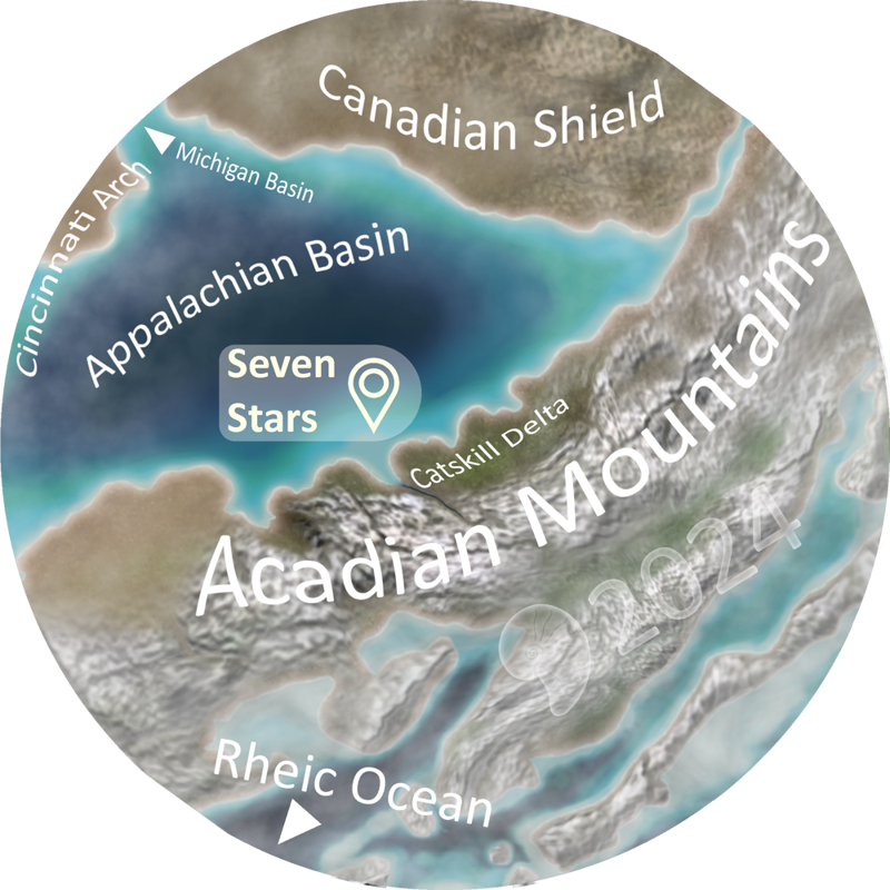
In the Mid Cambrian and continuing until the Early Ordovician Period, the Iapetus Ocean stopped growing and some volcanic island arcs broke away from Gondwana, drifting towards Laurentia (1,2). The Chopawamsic volcanic Island arc was active in the Cambrian, but then became extinct before the Ordovician. It and another microcontinent together moved, before fusing together. A new volcanic event ensued, as Arvonia was formed on top of the extinct Chopawamsic Island arc, culminating in a mountain belt composed of three subcontinents driving Northeast towards Laurentia. Arvonia was still active when the arc collided with Laurentia, in what is called the Taconic Orogeny. Laurentia had jagged coastlines, so not all areas were affected in the same way when the Taconic terrane collided with it, though Southwest Virginia and Eastern Pennsylvania were hit the hardest, causing a mountain range similar to the modern Alps to form as the Taconic terrane was pushed up onto the Laurentian plate. Because the Taconic terrane collided at an angle from the Southeast, Virginia was hit first and then Pennsylvania later. The ramp-like suture in between the two continents separated Early Paleozoic Sedimentary rocks on the Laurentian side and the Taconic Mountains on the other (see Figure 1). The Taconic terrane came with such force that an old fault from the Grenville Orogeny, the Haysville-Fries-Rockfish Valley Fault, was reactivated and part of Laurentia was pushed up onto itself. Above the Suture between the two continents, a shallow sea formed in the Central Foreland Basin, and was almost filled with sediment as the Taconic Mountains were eroded. Thus the Central Appalachian basin formed, an almost closed, very salty shallow sea bordered by sandy beaches and a large desert in Virginia. The sea shrunk through the Silurian and Early Devonian (1).
The Acadian Orogeny – Devonian and Mississippian Periods
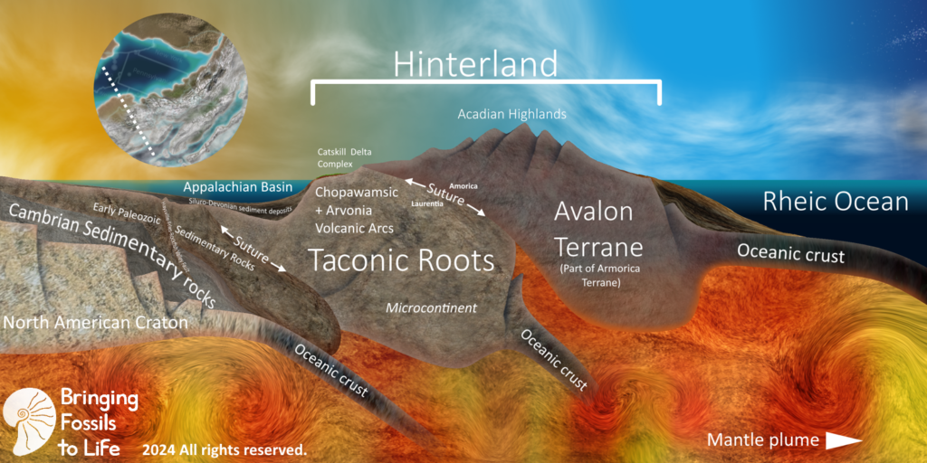
Up North, the Calcedonian Orogeny pushed a continent called Baltica into Laurentia (1,2). Back South, more subduction pulled a subcontinent called Armorica into Laurentia slowly (1,2). After the two orogenies would be completed, the resulting continent would be called Laurussia. The Armorican terranes, like the Taconic terranes, came from the Southeast, but unlike the Taconic terranes, they collided with the Northern portions of Laurentia first, and then swung around to hit the Virginia-Carolina region after Pennsylvania, due to their orientation. Avalon, the region of Armorica that was nearest Pennsylvania, was also volcanic in origin, and it too slid up an inclined suture to become a tall mountain range, this time being comparable to the modern Himalayas. This deformed the Taconic Terrane, and the weight of the new rock above it plunged the Taconic terrane farther down into the Earth, causing a great deepening of the Central Appalachian basin. Rivers from the new Acadian Highlands brought silica-based sediment down through a coastal plain, which became the Catskill Delta Complex (1). This was a region dominated by braided streams (4). Because the Acadian Mountain range was so high, it caused a dramatic rain shadow effect. Clouds that formed over the Rheic Ocean to the East were blown by tropical trade winds against Avalon, thus being forced to rise, cooling and releasing great amounts of moisture in the form of rain. Because this phenomenon is caused by orogenies, it is called orographic rainfall. Once the clouds were blown up and over the mountains, if they were even able to make it, they were dry before they arrived in the Catskill region. This meant that the region was very dry for most of the year, except when meltwater from the Acadian Highlands’ snow buildup surged down the rivers (1,4). It’s also possible that seasonal storms akin to hurricanes could have made it over the mountains, but these would have happened very rarely in the same spot (1).
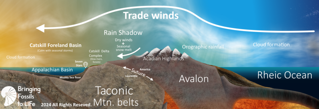
Seven Stars was part of the Mahantango Formation, which overlied the deepwater Needmore shale in age and position, as evidenced by the presence of plants that washed in from the Catskill Delta Complex, as well as the size of the clasts in the rock. It was deposited as the Catskill Delta Complex flooded, bringing sediment down from the Acadian Highlands, causing a submarine alluvial fan. Because of the position of this alluvial fan as found by geologists, it is likely that there was a rivermouth near where Harrisburg is now (5). Seven Stars was located in a shallow and very turbid region of the Mahantango area, as known from the presence of the Brachiopods Rhipidomella and Devonochonetes (5). It received seasonal mud from the mountains, fossilizing the vibrant ecosystem that was there. The coarsening up cycles that have been recognized in the Mahantango (5) can be seen at Seven Stars, as the lower collection area has smaller particle size than the upper collection area that is more fossiliferous.
Works cited
(1) Fichter, Lynn, & Baedke, Steve. (2000). 16 Page Geologic History of Virginia. James Madison University. csmgeo.csm.jmu.edu/geollab/vageol/vahist/16pghisH.html. Accessed 2 Aug. 2024. Click on the letters to the left to view the stages of the formation of the modern Appalachian Mountains.
(2) Spencer, Edgar W, & Spencer, Shawn. Guide to the Geology & Natural History of the Blue Ridge Mountains. Edgar W. Spencer, Virginia, 2017, p. Chapter 2 – pgs.17-33.
(3) Affolter, Matt, et al. (2020). The Acadian Orogeny – Historical Geology. Historical Geology. https://opengeology.org/historicalgeology/case-studies/acadian-orogeny/. Accessed 2 Aug. 2024.
(4) Murphy, Dennis. (2005). Devonian Times – Red Hill Geology. Academy of Natural Sciences, https://web.archive.org/web/20221007100257/http://www.devoniantimes.org/who/pages/geology.html. Accessed 2 Aug. 2024.
(5) Deptola, Travis. (2012). ORGANIZATION and DISTRIBUTION of MIDDLE DEVONIAN BIOFACIES within a SEQUENCE STRATIGRAPHIC FRAMEWORK, HUNTINGDON COUNTY, PENNSYLVANIA, USA. Penn State University.
https://etda.libraries.psu.edu/files/final_submissions/7793. Accessed 2 Aug. 2024.